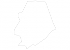
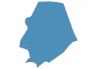
Niue Map - SVG Vector
Interactive Map of Niue
Niue is a Parliamentary system founded in 1974 and located in the area of Oceania, with a land area of 261 km² and population density of 7 people per km². Territory of Niue borders Pacific ocean. Gross domestic product (GDP) is of about 100100 millions of dollars dollars.
Geography of Niue
Mutalau on Niue is the highest point in Niue at an altitude of 68 meters, instead the lowest point in the country is South Pacific Ocean at sea level.
Simple Maps of Niue
Here are the best maps of Niue at high resolution. Below you find printable maps showing Niue in different styles and positions.

Frequently asked questions about Niue
How is Niue divided?
If you are looking for regions or provinces in Niue, here are all the main areas:
- Niue
What are the main points of interest in Niue?
The major tourist attractions in Niue are Limu Pools, Utuko Beach, Palaha Cave, Taoga Niue Museum, Ekalesia Church, Talava Arches, Hio Beach, Avaiki Cave, Avatele Beach.
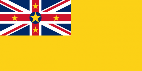
What is the flag of Niue?
What is the capital of Niue?
The main city and capital of Niue is Alofi.
What is the currency in Niue?
Official currency of Niue is Dollar.
What is the population of Niue?
In Niue there are 1700 people.
What is international phone code in Niue?
Niue telephone code is 683.
Other Country Maps in Oceania
Get Full Access
1) Access Map Editor
(create interactive maps)
2) Get 230+ country flags
(100% licensed vectors and images)
3) Get 230+ country maps
(100% licensed vectors and images) Get Full AccessOnly $4/month ($47 for 1 year)
After expiration, you have full licenses of all your downloads forever.