Maldives Map - SVG Vector
Interactive Map of Maldives
Maldives is a Republic founded in 1965 and located in the area of Asia, with a land area of 301 km² and population density of 1799 people per km². Territory of Maldives borders the sea. Gross domestic product (GDP) is of about 227000 millions of dollars dollars.
Geography of Maldives
Mount Villingili on Villingili is the highest point in Maldives at an altitude of 5 meters, instead the lowest point in the country is Indian Ocean at sea level.
Simple Maps of Maldives
Here are the best maps of Maldives at high resolution. Below you find printable maps showing Maldives in different styles and positions.
Frequently asked questions about Maldives
How is Maldives divided?
If you are looking for regions or provinces in Maldives, here are all the main areas:
- Central
- Malé
- North
- North Central
- South
- South Central
- Upper North
- Upper South
What are the main points of interest in Maldives?
The major tourist attractions in Maldives are Meeru Island, Ari Atoll, Malé Atoll, Maafushi, Hulhumale, Kuramathi, Hukuru Miskiy, Vaadhoo, Nalaguraidhoo.
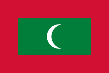
What is the flag of Maldives?
What is the capital of Maldives?
The main city and capital of Maldives is Male.
What is the currency in Maldives?
Official currency of Maldives is Rufiyaa.
What is the population of Maldives?
In Maldives there are 541500 people.
What is international phone code in Maldives?
Maldives telephone code is 960.
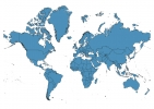
Other Country Maps in Asia
Get Full Access
1) Access Map Editor
(create interactive maps)
2) Get 230+ country flags
(100% licensed vectors and images)
3) Get 230+ country maps
(100% licensed vectors and images) Get Full AccessOnly $4/month ($47 for 1 year)
After expiration, you have full licenses of all your downloads forever.